- Messages : 20
- Remerciements reçus 0
What are these symbols?
- cdocsail
- Auteur du sujet
- Hors Ligne
- Membre junior
-

Moins
Plus d'informations
il y a 1 an 8 mois - il y a 1 an 8 mois #2541
par cdocsail
What are these symbols? a été créé par cdocsail
I have qtVLM and the Caribbean chart pack. In the image below are two yellow trapezoids which I have circled in red.
What are these?
In one of the circled areas, what does 'Laure' signify?
What does the number next to it (41040) signify?
I right click, select vector chart elements and get a dialog that says it's a special purpose buoy
FL (4) 20s
So FL means fixed light
Does (4) mean visible for 4 miles?
what is happening at 20s?
Dernière édition: il y a 1 an 8 mois par cdocsail.
Connexion ou Créer un compte pour participer à la conversation.
- maitai
- Hors Ligne
- Administrateur
-

Moins
Plus d'informations
- Messages : 1052
- Remerciements reçus 7
il y a 1 an 8 mois - il y a 1 an 8 mois #2542
par maitai
Réponse de maitai sur le sujet What are these symbols?
These are special purpose buoys, in that case ODAS (Ocean Data Acquisition System) which you can learn via the pick-up report (right-click, vector chart elements). Laure is just the name of the buoy, as is 41040
FL 4 20s means a Flashing Light visible at 4 miles flashing every 20 seconds.
A Fixed Light would be just F
See this post for a similar question: www.meltemus.com/index.php/en/forum/qtvl...hart-packs-rncs#2503
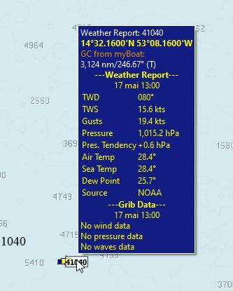
Btw if you load weather buoys data (right click, weather stations download), you will even learn about the data the buoy is collecting
Dernière édition: il y a 1 an 8 mois par maitai.
Connexion ou Créer un compte pour participer à la conversation.
- cdocsail
- Auteur du sujet
- Hors Ligne
- Membre junior
-

Moins
Plus d'informations
- Messages : 20
- Remerciements reçus 0
il y a 1 an 8 mois #2547
par cdocsail
Réponse de cdocsail sur le sujet What are these symbols?
thank you for that. I could reproduce this info for marker 41040 but not for the others (41041 or 41300 or Laure) Does this mean there is no data for those markers?
Connexion ou Créer un compte pour participer à la conversation.
- maitai
- Hors Ligne
- Administrateur
-

Moins
Plus d'informations
- Messages : 1052
- Remerciements reçus 7
il y a 1 an 8 mois #2548
par maitai
Réponse de maitai sur le sujet What are these symbols?
I suppose the data for these stations is not published by NOAA.
Connexion ou Créer un compte pour participer à la conversation.
Temps de génération de la page : 0.124 secondes


